The ability to accurately monitor and assess agricultural activities in Sudan is of paramount importance for planning and implementing interventions related to food security and strengthening food system resilience. While anecdotal reports suggest a significant reduction in the cultivated agricultural land in the current season compared to previous years, there is a significant gap in studies that quantitatively estimate the areas cultivated during the 2023/24 agricultural summer season.
This study aims to bridge this research gap through the development of a robust methodology that leverages remote sensing imagery and machine learning classification. We present a comprehensive model, which we employed to derive estimates of cultivated agricultural land in Gezira state, spanning the timeframe from 2019 to 2023. We firmly believe that our method will serve as a vital tool for policymakers, aid organizations, and local and regional food security stakeholders. It will equip them with both granular and macro-level insights into agricultural activity not only in Sudan but also in challenging, hard-to-reach locations.
We introduce a land cover classification model designed to distinguish cultivated agriculture from uncultivated lands within the Gezira irrigation schemes. Our model’s evaluations consistently yield robust accuracy levels, ranging from 92.26% to 99.98%, with true positive rates (TPR) and true negative rates (TNR) consistently exceeding 90% in most years. These results underscore the model’s reliability in discriminating between cultivated and uncultivated croplands.
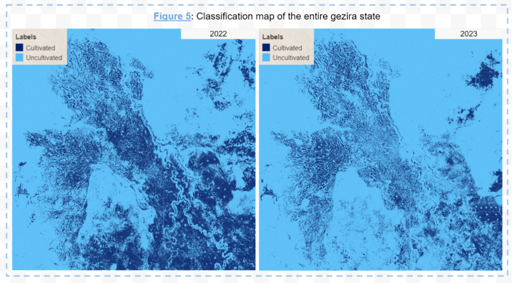
This report underscores a substantial decline in sowing activities within the Gezir state, specifically the Rahad and Gezira Schemes. For the current agricultural season (2023/24), estimates place cultivated lands in the Gezira Scheme area between 734K and 1,060K Feddans, significantly below the five-year average ranging from 1,041K to 1,268K Feddans. The reduction in the Rahad scheme area is even more pronounced, with estimated cultivated areas for the current year spanning from 168K to 229K Feddan, considerably less than the five-year average of 285K to 327K Feddans. The figure below provides a comprehensive qualitative assessment of cultivated lands in Gezira State in 2023 (right) compared to 2023 (left). The visual representation vividly illustrates the substantial decrease in cultivated land for the current agricultural season, particularly in the central areas of the Gezira scheme.
Backed by robust qualitative and quantitative validation, our approach holds significant promise for practical implementation in agricultural monitoring within complex settings. Furthermore, the integration of Machine Learning techniques with Satellite data, as demonstrated in this research, offers substantial potential for addressing data gaps, not only in Sudan but also in challenging, hard-to-reach locations. Its capacity to deliver real-time, large-scale insights into land use, crop health, and environmental conditions equips stakeholders with the knowledge needed to make informed decisions, allocate resources efficiently, and respond effectively to emerging challenges.
This publication is part of our ongoing efforts to provide reliable and effective decision making support to the local food security stakeholders in Sudan. If you’re interested in collaborating or in learning more about our research capabilities, please don’t hesitate to get in touch with us today.